Staying on Course with GPS-Enabled Dispatch
Following the tragic crash of Korean Air Lines Flight 007 in 1983, the U.S. government made a pivotal decision that would reshape how we navigate our world. Announcing that the Global Positioning System (GPS) would be made available for civilian use, the aim was to enhance navigation and boost the safety measures for air traffic. Fast forward to today, and GPS technology is everywhere in aviation and almost every electronic device we possess.
We integrated GPS functionality into the Engage Mobilize Mobile App to enhance the value and utility of the Engage Mobilize platform to drive higher efficiency and productivity.
Engage Mobilize GPS Capabilities
The Engage Mobilize platform leverages GPS technology to dramatically improve field service's transparency, productivity, efficiency and safety. The E-Ticketing platform, which set the standard for electronic field tickets in the Oil and gas industry, integrates existing GPS technology into the Engage Mobilize Mobile App. Integrating GPS tracking into field ticketing systems is one of the Best Practices we identified in our case studies.
The three significant GPS-enabled capabilities leveraged by the Mobile App include geofencing, geolocation and GPS directions. Let's briefly cover each one.
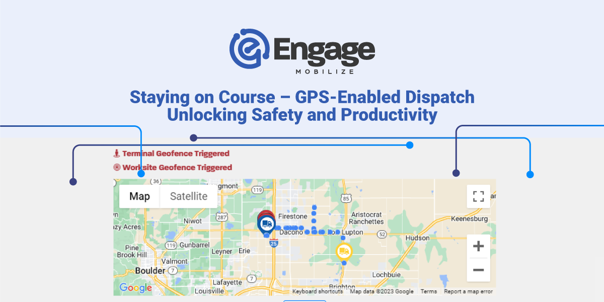
Geofencing. Geofencing is a location-based technology that defines a virtual boundary around a real-world geographical area, like a well site or water disposal facility. It essentially allows for creating an electronic "fence" around a specified location using GPS, RFID, Wi-Fi, or cellular data. Once this "fence" is established, the Engage Mobilize Mobile App can trigger a response when a service crew enters, exits, or remains within the defined perimeter.
Geolocation. Geolocation is the ability to identify the geographical position or location of a person or object, such as a workover unit or water-hauling transport. This location data can be precise (pointing to a particular well site) or more general (like an oilfield or area of operations).
GPS Directions. The Engage Mobilize Mobile App can automatically feed destination coordinates to proven GPS apps (e.g., Google Maps), guiding a user from a starting location to a designated destination. These directions are based on the real-time geographical position of the user (geolocation), determined by signals from the global GPS orbiting the Earth.
GPS functionality in the Mobile App serves all 250+ job service types covered by the E-Ticketing platform, from produced water hauling to crude oil transport, hourly crews and roustabouts, chemicals and inventory tracking, and more. Every one of these field services requires getting from Point A to Point B, and with the power of the Mobile App enabled with GPS, driver and crew whereabouts can be tracked and verified throughout the lifecycle of the service performed.
How it Works - Technological Synergy
When combined with other technologies used in Oil and gas operations, GPS-enabled functionality can significantly improve efficiency and productivity, driving cost savings. The best way to illustrate this potential is a recent case study.
A large independent Oil and gas operator operating over 400 wells in its primary area of operations adopted the Engage Mobilize Platform, including Predictive Dispatch capability, to improve water logistics for both produced water and flowback water.
Predictive Dispatch automatically compares water tank levels using the existing SCADA system. Water orders are automatically generated when tanks approach full capacity at a well site. Then, dispatchers can use the Engage Mobilize platform to assign the order to the water hauling unit nearest the location (geolocation). A turn-by-turn route to the correct well location is automatically delivered to the driver via the Engage Mobilize mobile application (GPS directions). Once the water transport reaches the well site, the work status is automatically triggered (geofencing). The dispatcher or operator can also assign the correct water disposal facility, which can be routed to and verified similarly.
Using Predictive Dispatch combined with GPS-enabled features and directions, the operator realized a 20% reduction in cost per ticket for an estimated $1.4 million in annual savings.
“We are seeing reduced hours per ticket by continuously (in real-time) monitoring our vendor routes, which helps us maintain cost at or below budget in this market.”
- Water Dispatch Foreman
Benefits of GPS-Enabled Dispatch
We have summarized some of the benefits of GPS-enabled functionality below.
Verification of Service. In a sector where accountability is crucial, GPS and geofencing data act as a reliable testament. It provides tangible proof of a job’s completion, duration and the personnel involved.
Transparency. With geofencing, managers and stakeholders have near real-time access to service crew locations, times, activities and work statuses. This offers a critical window for evaluating crew and job performance.
Work Phase Time Tracking. GPS functionality also allows the Engage Mobilize platform to track time spent in each phase of a job, not just the time from origin to destination and the elapsed time on location. Having this data helps establish benchmarks and evaluate the performance of service companies.
Safety. Safety is paramount, especially in field services. The GPS integration in the Engage Mobilize app takes this seriously by automatically selecting the most efficient and safest routes, thus decreasing the time spent on the road or “windshield time.”
Compliance with Lone Worker Regulations. The Engage Mobile App can help comply with OSHA 1915.84, covering requirements for working alone and providing the ability to account for and communicate with individuals in the field.
Restricted Road Reporting. The Mobile App’s breadcrumbing feature can identify when and where vehicles drive into restricted areas and use restricted roads. This information is helpful for evidencing compliance and simplifying reporting.
Satellite Mapping. The Mobile App is equipped with satellite mapping, which provides GPS-enabled features when navigating remote lease roads outside the cellular service range.
Data Analytics and Insights. GPS doesn't just guide – it informs. With the rich data harvested, companies can delve deeper into performance evaluation, optimization strategies, and detailed analysis.
Reduced Operational Costs. Efficient routes equate to savings. Fewer miles driven means reduced costs on vehicle maintenance, repairs, and fuel.
Summary
The journey of GPS ranges from ensuring the safety of airplanes to reshaping field service operations is one of technological advancement and evolution. Engage Mobilize pioneered the use of GPS in delivering and managing oilfield services, making the oilfield more efficient, productive, environmentally conscious, and safe.
The oilfield never rests; in a world of constant motion, having the right direction makes all the difference.
Contact us today at (720) 575-6695 or Sales@engage-m.com to learn how Intelligent Field Automation Software from Engage Mobilize can help you achieve new levels of operational efficiency and create a competitive advantage.
Share this
Field Service Dispatch Software – Unifying Operators and Service Providers

Integrating Field Operations Software: Unifying Your Systems into One Integrated Solution